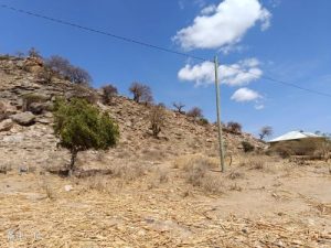
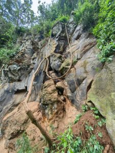
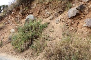
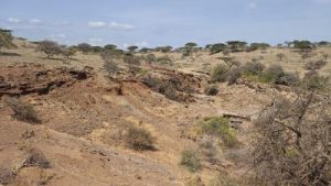
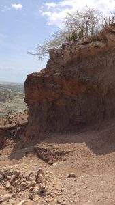
The geomorphic unit of this point is a basin, with a steep slope as the micro landform. The lithology is granite, with a medium to coarse grain structure and a block like structure. The rock is strongly weathered, with well-developed joints and fissures. The vegetation is shrubs, and there is no human engineering activity. The collapse source is an isolated and dangerous rock mass, approximately 25m long, 12m high, and 5m wide. The rock is granite with strong weathering and currently has joints and cracks. The collapse path is to fall down the slope and then pile up to the foot of the slope. Currently, there are scattered deposits in the collapse path area. The hidden danger point of the collapse is currently in the initial cracking stage, with developed joints and cracks on the slope. It is currently in a basically stable state and may become unstable under the influence of triggering factors such as rainfall and earthquakes, resulting in collapse. This point is an isolated and dangerous rock mass, with a height of about 12m and a length of about 25m. There is relatively little human activity and the degree of harm is small.

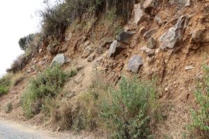
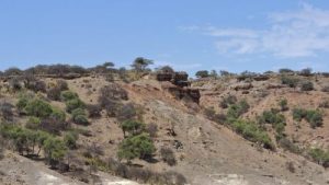
The geomorphic unit of this point is a basin, with a steep slope as the micro landform. The lithology is granite, with a medium to coarse grain structure and a block like structure. The rock is strongly weathered, and the vegetation is shrubs. There is no human engineering activity. The collapse source is formed by steep slope terrain, with a length of about 100m, a width of about 3m, and a thickness of about 2m. The joint fissures are well-developed, and the rock is granite with strong weathering. The collapse path is that the rock falls downwards along the structural plane under the combination of weathered joints and fissures, and accumulates at the slope angle under the inducing factors. The hidden danger point of the collapse is currently in the initial cracking stage, with a small amount of scattered rolling stones in some areas. It is currently basically stable and may become unstable under the influence of triggering factors such as rainfall and earthquakes, resulting in collapse. This hidden danger mainly poses a threat to nearby residents, including 2 households with about 12 people, 3 brick and concrete houses, and 2 adobe houses, posing a threat to property worth 160000 yuan. The number of threats ranges from 10 to 100 people, with a moderate degree of harm.
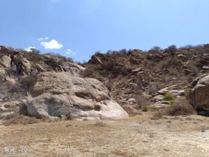
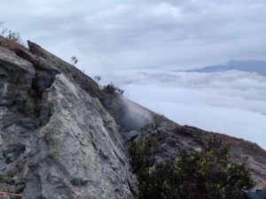
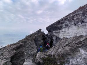
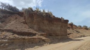
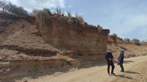
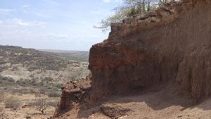
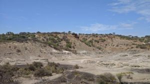
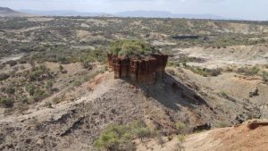
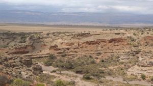
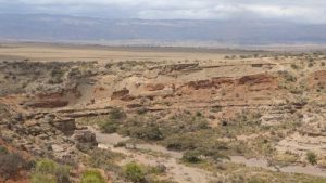
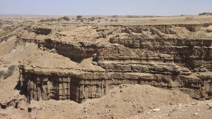
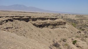
The terrain and topography of this point are Zhongshan, with steep cliffs as the micro terrain. The upper part is composed of calcareous tuff, gray white, with multiple sets of vertical joints. The bottom is composed of basalt, gray black, and the slope is nearly horizontal layered. The vegetation is shrubland, and human engineering activities are road construction. The collapse source area is mainly a dangerous rock mass formed by calcareous tuff due to columnar joints, with a spacing of about 1 meter and a depth of about 8 meters between the columnar joints. The collapse path area is a dangerous rock mass that rolls and jumps on the slope after dumping, with a maximum distance of about 60m. At present, the dangerous rock mass is in a basically stable state, and may experience instability and collapse under triggering factors such as rainfall and earthquakes. This is an undeveloped scenic spot, with inconvenient road traffic and limited human traffic, resulting in a low level of harm.
The terrain and topography of this point are Zhongshan, with steep cliffs as the micro terrain. The upper part is composed of calcareous tuff, gray white, with multiple sets of vertical joints. The bottom is composed of basalt, gray black, and the slope is nearly horizontal layered. The vegetation is shrubland, and human engineering activities are road construction. The collapse source area is mainly a dangerous rock mass formed by calcareous tuff due to columnar joints, with a spacing of about 1 meter and a depth of about 8 meters between the columnar joints. The collapse path area is a dangerous rock mass that rolls and jumps on the slope after dumping, with a maximum distance of about 60m. At present, the dangerous rock mass is in a basically stable state, and may experience instability and collapse under triggering factors such as rainfall and earthquakes. This is an undeveloped scenic spot, with inconvenient road traffic and limited human traffic, resulting in a low level of harm.
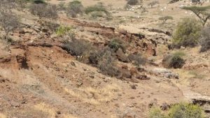
The surrounding terrain of this hidden danger point is steep, with a slope of 50-70 °. The terrain is a low mountain in a volcanic crater, and the roadbed slope is manually excavated. The lithology of the formation is a mixture of Quaternary residual soil and rock mixed with crushed stone soil. The soil is completely weathered tuff powder, with a crushed stone content of about 50-70%. The block size is 3-150cm, and the sorting is poor, with an angular shape. The parent rock is composed of tuff (volcanic rock), and there is no water in the surrounding area. The surface vegetation is covered, mainly by herbs and shrubs, Human engineering activities mainly involve excavating mountain roads, with a roadbed width of approximately 3-4m The source area of the potential collapse hazard is the slope of the entrance road to the Engro Huoshan Pass, which is residual gravel soil with a maximum block diameter of up to 1.5m. The slope is steep, with a slope of 60 ° -80 °. The roadbed side is exposed, with visible fragments, with a block diameter of 10-30cm. The upper part of the slope is covered with vegetation. The collapse path falls downwards along the slope to the foot of the slope, with a maximum distance of 50m along the slope, usually 20m, and piles up at the foot of the slope. The hidden danger point is currently in a basically stable unstable state, with a small amount of falling stones visible on the roadbed. In the future, under triggering factors such as rainfall, larger stones may fall, affecting the safety of passing vehicles. The hidden danger point is currently in an unstable state and is prone to collapse under triggering factors such as rainfall and vibration excavation, causing harm to passing tourist vehicles with a moderate degree of harm. Tourist vehicles can accommodate 5-9 people, with a moderate to high degree of harm.
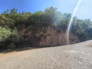
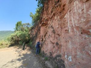
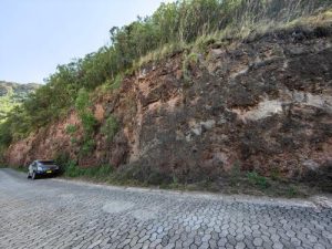
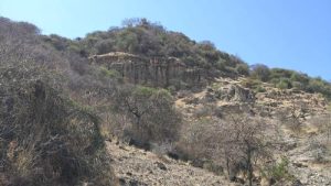
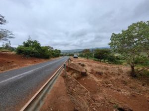
The surrounding terrain of this point is steep, with a terrain of medium to low mountains and hills, with a slope of 30-50 °. The lithology of the strata is volcanic tuff and volcanic ash, a combination of hard and soft strata. The area is also formed by manual excavation, with a slope of about 60-70 °. The rock mass is fragmented, and the surrounding vegetation is covered. Below the foot of the slope is farmland. The collapse source area is located on the south side of the highway, forming a free face for road construction and excavation. The rock mass in the source area is broken and fragmented, with a diameter of 30-80cm. The residual soil on the surface slope is thin, 10-30cm, covered with vegetation, and the free face is exposed. The collapse path rolls down the slope, piled up at the edge of the roadbed, and can roll down to the farmland at the farthest point. The slope is currently in a basically stable unstable state, and during the rainy season, it can cause the rolling of rocks under the induction of rainfall. The hidden danger point is currently in a basically stable unstable state, which can form collapse under triggering factors such as rainfall, seriously affecting the safety of passing vehicles and personnel, with a moderate degree of harm.
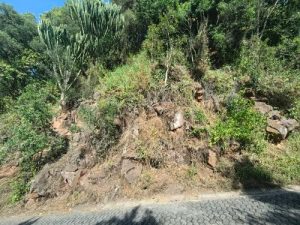
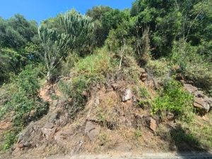
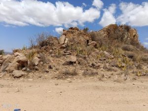
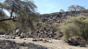
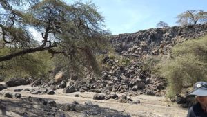
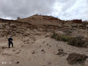
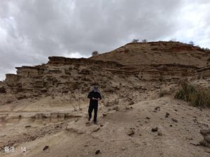
The terrain of the collapse site is steep, with hilly terrain and volcanic rock formations. The rock mass is fragmented and has developed joints, with a slope of 40-70 °. Most of the surface has been exposed, with a small number of cactus trees visible. There is only one road around, paved with gravel, and no other human engineering activities. The terrain of the collapse source area is steep, with a slope of 50 ° -70 °. The rock mass is fragmented, with vertical joints developed, and the rock mass is fragmented, with a block size of about 0.3 × 0.5 × 1.5m The collapse path falls down along the mountain, with a path that is approximately straight and piled up at the foot of the slope. The collapse point is currently in a basically stable unstable state, and can cause collapse phenomena such as falling rocks under triggering factors such as rainfall and earthquakes. The collapse point mainly falls down the mountain in the form of rolling stones, which mainly endangers the safety of pedestrians and vehicles passing by the slope foot road, and the degree of harm is relatively small.
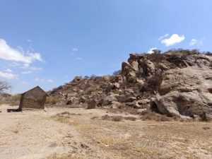
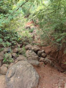
This point is located in a gully, with volcanic breccia as the lithology. The steep slope is nearly upright, with a combination of tuff/breccia/tuff. The surface is covered with shrubs and a small amount of trees. There is a road at the top of the slope, which is about 5m wide and paved with gravel. The top of the collapse source slope is relatively gentle, and the slope surface is nearly upright, consisting of volcanic breccia with developed vertical joints and unstable rock structure. The collapse path tilts downwards along the slope and rolls into the ditch. The collapse hazard point is currently in a state of extreme equilibrium and can cause collapse under factors such as rainfall. The hidden danger point is located on the east side of the highway roadbed, collapsing towards the direction of the highway, endangering the highway and passing vehicles and pedestrians, with a relatively low degree of harm.
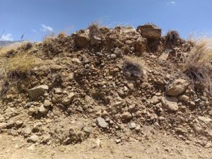
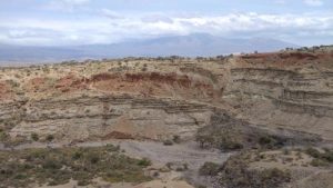
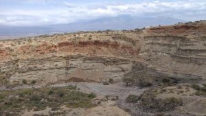
The surrounding terrain of this point is relatively undulating, with a slope of 5 ° -30 °. The terrain type is medium low mountain terrain, and the lithology of the stratum is basalt. The slope at this point has a slope of about 15 ° -30 °. The rock mass on the slope is fragmented, with a block diameter of 10-30cm and an angular shape. There are many trees around, with a height of about 5-18m and a thickness of about 10-20cm. Herbs, shrubs, and other vegetation can be seen on the slope. The slope gradient of the collapse source area is about 30 °, and the rock structure is fragmented, presenting a fragmented to scattered shape with a block diameter of 20-30cm and an angular shape. Herbs and shrubs can be seen on the slope surface. The collapse path rolls downstream along the slope. At present, the slope is in a basically stable state, and under the action of heavy rain or earthquakes, the stones on the slope will roll down along the slope. The slope is currently in a basically stable state, with landslides occurring mainly during the rainy season. The dry season has little impact on the safety of passing vehicles and pedestrians, and the degree of harm is low.
Properties and Characteristics(Monomer properties, form, structure, external manifestations and internal factors of components,As well as main environmental factors such as the monomer generation process, evolutionary history, and personnel influence.) The lion population at Ngerongoro Crater is of unique importance. since 1963It has been studied almost continuously for decades and is the best-known and best-studied lion population in the world. Physically separated from the lion population in nearby Serengeti National Park, the Crater Lions have become a textbook example of the challenges faced by an isolated, inbred population. 1962In 2000, the lions in Ngerongro Crater experienced a population bottleneck due to a mass extinction that left only a few survivors. Over the next decade, three different male alliances formed and reproduced. Crater lion populations recover rapidly, to80Already in the mid-1900s100Many lions. Successful prides on the crater floor gave rise to large tribes of male lions. Over the next few years, they will produce all their offspring until they are chased away by their own adult sons. The lions at Ngerongoro Crater are therefore the offspring of long-term inbreeding, with male lions giving birth to cubs from blood-related female lions.2013In 2000, an outside tribe of male lions emerged from the Ngorongro Crater and successfully introduced new genes into the hybrid population. Their entry resulted in a boom in pups with high survival rates. One possible reason for increased fertility could be the influx of new genes.Because many cubs are born together and are well protected, their chances of survival are greatly increased.2014New Year’s Eve2018During the year, a large number of cubs are born, and many survive to adulthood. Then the reproductive rate continued to decline thereafter. In the past few years, by 5powerful alliance of two male lions dominates the crater, which is inaccessible to other male lions in the pride. Although the situation is stable, the number of lions in the crater is currently smaller than before. According to statistics, there are approximately70Many lions. Adolescent male lions are driven out of the crater, and no other male lions are allowed in the crater.

Properties and Characteristics(Monomer properties, form, structure, external manifestations and internal factors of components,As well as main environmental factors such as the monomer generation process, evolutionary history, and personnel influence.) The Ngaruka site, located in the northwestern Munduli district of central Arusha region, is one of the most important Iron Age archaeological sites in East Africa, with its origins dating back to15century. These ruins are1883Gustav·Fischer was first discovered by a German scientist who likened it to the collapsing walls of an ancient castle. They are known for their complex irrigation and farming systems, which include stone-lined canals that channel water from the rift valley cliffs to multiple stone-lined farming terraces. The main crop is sorghum. Scientists have confirmed that Ngaruka was once home to seven villages and an irrigation system that supported20square kilometers of farmland. exist18The area was suddenly abandoned in the middle of the century, probably due to reduced river flow and/or conflicts with other tribes. These residents were likely the ancestors of today’s Iraqis, who today use similar sophisticated irrigation techniques.
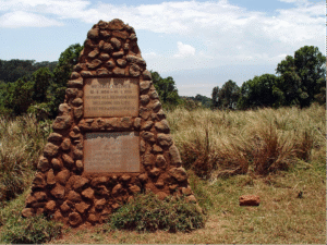
Properties and Characteristics(Monomer properties, form, structure, external manifestations and internal factors of components,As well as main environmental factors such as the monomer generation process, evolutionary history, and personnel influence.) Tomb of Grizmaek (Grizmek Grave) is located on the west side of Ngorongro Park on the side of the road. It is in the shape of a triangular pyramid and is made of stones. This monument is the work of Bernhard, the famous German zoologist and conservationist.·Clemens·Maria·Gzimek (1909-1987) and his son Michael·Gzimek (1935-1959)’s resting place.Their most important work is the novel and film ‘The Serengeti Will Not Die’ of the same name. This movie is in1959Won the Academy Award for Best Documentary in 2011. Both works led to the creation of the Serengeti National Park.1959Michael died in a plane crash during filming.1987Bernhard died in Frankfurt in 2001 and his ashes were later transferred to Tanzania and buried alongside his son Michael next to Ngorongoro Crater.
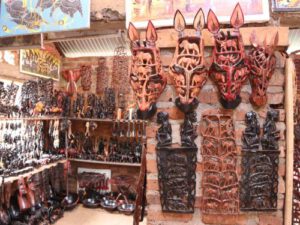
Properties and characteristics (external manifestations and internal factors of the individual properties, shape, structure, components, as well as main environmental factors such as the individual generation process, evolutionary history, human influence) Makonde Carving The ruins point is located about 5 kilometers north of the center of Karatu town and takes about 10 minutes to drive to. Craftsmen can be seen carving their works here, and there are shops for visitors to browse or buy goods. The Makonde people are an ethnic group in southeastern Tanzania and northern Mozambique. They are famous for their wood carving skills. The Makonde are one of the few matrilineal societies in Tanzania where kinship ties are traced through women and husbands moving into their wives’ villages. Traditionally the Makonde people use ebony. Carved household items and dance masks from mahogany and mahogany. Once their carvings became famous outside Africa, the Makonde people expanded the scope of their work to include many new objects of beauty and utility. These carvings are extremely complex and often large in scale. These wood carvings can depict traditional stories or feature a series of animals. Makonde carvings are often found in hotel lobbies and gift shops across Tanzania. The art of carving is passed down from generation to generation.
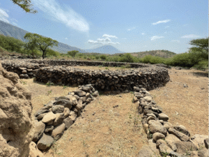
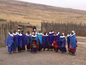
Properties and characteristics (external manifestations and internal factors of the properties, form, structure, and components of the single entity, as well as major environmental factors such as the single entity generation process, evolutionary history, and personnel influence) Seneto Masai Cultural Village (Seneto Masai Cultural Village) Cultural Boma) is located on the west side of Ngorongro Park, 400m from the Crater East Observation Deck. The cultural village covers an area of about 5Km2, is oval in shape, and is surrounded by fences on the outside. There are Maasai people greeting tourists at the entrance of the Cultural Village. The Seneto Maasai Cultural Village was built in 1992 and is the oldest of the five Maasai cultural villages in the geopark. The cultural village was established to allow tourists to understand the Maasai lifestyle in the local community by participating in geotourism. Seneto Cultural Village is sponsored by the Ngerongaro Conservation Area Authority and the Ngerongaro Pastoral Council. The cultural village is located within the Ngorongaro Conservation Park, which includes three villages – Oloirobi, Kayapsi and Misigyo. The use and management of the cultural village is carried out in rotation among the three villages, with each village staying for one year. At the cultural expo, visitors can see the Maasai lifestyle, taste their food, enter their houses, participate in their dances, listen to their folk stories, and buy their goods. Visitors to the Cultural Village need to pay an entrance fee, which goes into the Cultural Village’s basket fund. The money raised is used in a variety of ways: some of the funds help support the Maasai who remain in the cultural village, other funds are used to purchase livestock, and a small amount is used for the village as a whole.
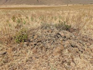
Properties and characteristics (external manifestations and internal factors of the individual properties, shape, structure, components, as well as the main environmental factors such as the individual generation process, evolutionary history, human influence) The tomb of the leader of Dadoga is made of stones. Covered, weeds grow around the area, and there are no signs or markers. In the early 19th century, the Dadoga people lived in Ngorongoro Crater. However, in the mid-19th century, the Dadoga were attacked by the Maasai, which led to a war between the two tribes. The Dadoga eventually moved south to an area near Lake Eyasi. An important spiritual leader of Dadoga named Gitanda was killed with a spear by the Maasai. His grave and the graves of several others are located at this location. These tombs are today the most important pilgrimage sites for the Dadoga tribe. Every few years, the Dadoga people organize a pilgrimage to the tomb to pray to their late chief for deliverance from any crisis they face. Some of them come from Sinyanga on Lake Victoria. The pilgrimage is usually carried out by women and elderly people, who carry milk, beer brewed with honey, the meat of rams (killed in the traditional way) and tobacco. The group would drink some of the milk and honey, and the rest would be poured on the stones of Gitanda’s tomb while the leader prayed. Afterwards, tobacco and ramskins were left on the grave. This ceremony is performed on all the graves as well as on a large fig tree nearby (the Sacred Tree of Dadoga). At the end of the ceremony, people collect some soil from the graves and sacred trees and take it home.
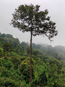
Properties and characteristics (external performance and internal factors of the individual properties, morphology, structure, components, as well as main environmental factors such as the individual generation process, evolutionary history, human influence) Pillarwood (Pillarwood or Cassipourea malosana) It is a tall evergreen tree that can reach a height of 45 meters (147 feet). It is characterized by a straight trunk and a small, rounded crown. This wood is highly valued and is used for flooring, furniture, cabinets, and many other purposes. When post wood is exposed to the elements, its durability decreases, limiting its suitability for outdoor use.
Properties and characteristics (external manifestations and internal factors of the individual properties, shape, structure, components, as well as main environmental factors such as the individual generation process, evolutionary history, human influence) Dadoga Sacred Tree consists of multiple large fig trees It is composed of an overall width of about 5m and a height of about 20~30m. Its origin is closely related to the story of the Dadoga tribe. In the early 19th century, the Dadoga people lived in the Ngorongoro Crater. However, in the mid-19th century, the Dadoga were attacked by the Maasai, which led to a war between the two tribes. In a battle, an important spiritual leader of Dadoga named Gitanda was killed with a spear by the Maasai people, and his eldest son Magusah was shot in the leg by a Maasai spear. He crawled back to his territory and called to his wife. His wife heard this and came to Magusah with a ladle of milk. When they met, he drank the milk from the gourd and said goodbye to his wife. He was never seen again and his body was never found. The large fig tree in this place marks the spot where Magusak took his last sip of milk.
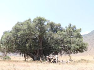
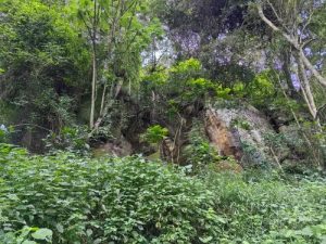
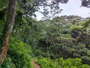
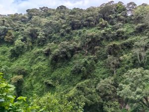
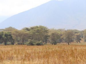
Properties and characteristics (external manifestations and internal factors of the individual properties, morphology, structure, components, as well as main environmental factors such as the individual generation process, evolutionary history, human influence) Lelai Forest covers an area of about 5 square meters km, is the most important forest within the crater. It is home to the yellow fever tree (Acaciaxanthongropea) and provides a special habitat for many different species of animals, especially rhinos and elephants. ‘Lerai’ is the Maasai word for tall yellow-skinned acacia tree. These beautiful trees are old and gnarled because every time the elephants peel off the bark, it grows back. Yellow fever trees are actually not related to yellow fever, except that they tend to grow in swampy areas where mosquitoes (carriers of yellow fever) are also common. Lelei Forest is also an exceptional bird habitat, providing food and nesting sites for hoopoe, cuckoo and weaver birds. The Lelai Forest was formed in the northwest of the Ngorongro Crater, close to the high mountains. There are two small streams that flow all year round through the area, providing water sources in the area for the growth of large trees, forming forest landscape.
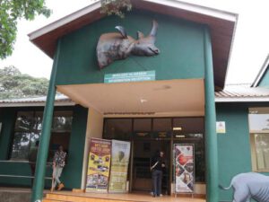
Properties and characteristics (external manifestations and internal factors of the individual properties, form, structure, components, as well as main environmental factors such as the individual generation process, evolutionary history, human influence, etc.) Ngorongro Gate Exhibition The center is located at the entrance of the Ngorongro Geopark and displays the geology, ecological environment and folk culture of the area in categories. There is also a small shop in the center selling food and drinks, as well as tourist guides and local products. Information about the Geopark can be found on display boards, which display maps, routes and attractions of the park. There is a large three-dimensional terrain model in the exhibition center for reference. The entrance to the exhibition center is still home to a large group of baboons. Visitors need to be aware of these baboons as they are used to begging for food from humans.
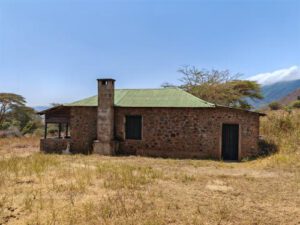
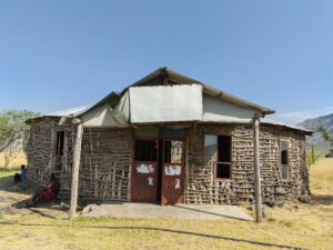
Properties and characteristics (external manifestations and internal factors of the individual properties, shape, structure, components, as well as main environmental factors such as the individual generation process, evolutionary history, human influence) The old German house is located in the southwest of the crater , the interior is a one-bedroom apartment with one bedroom, one bathroom and a kitchen. The house is fully equipped with beds, cabinets, chairs and other daily necessities. There are images of the owner and his family img on the wall. It was built by the German brothers Adolf and Friedrich Siedentop. Adolf entered the crater in 1899 and was initially a local shantytown dweller. He eventually leased some land from the government in German East Africa. He was later joined by his brother Friedrich and they began growing sisal, a plant used to produce fiber. The brothers developed a sizable farm and built a substantial stone house that continues to exist to this day. In 1916, two years after the outbreak of World War I, the brothers were expelled from the crater. In 1920, the house and farm were taken over by the British. The British later established a veterinary camp near Lerai and John Harman took over the farm. Next in charge was Captain Hurst and later Eric Howe. The house now falls under the jurisdiction of Lelay Post.
Properties and characteristics (external manifestations and internal factors of the properties, form, structure, and components of the single body, as well as main environmental factors such as the single body generation process, evolutionary history, human influence, etc.) Engare Sero Museum Founded in 2014, it is located in Ngaresero Village, south of Lake Natron in northern Tanzania. Ngareseiro Museum was established by the Maasai community of Ngareseiro village to showcase local Maasai culture. Currently, due to financial reasons, the objects in the museum have been stored and are no longer on display, and the museum is also waiting for renovation and reopening. The Ngareseiro Museum is built with traditional materials and contains traditional tools used by the Maasai people for work. In the museum, people can find information about the political culture, economy, and social culture of the local Maasai people. The museum also displays musical instruments used by the Maasai people, as well as information about Lake Natron and its surroundings. The Ngareseiro Museum has received approximately 6,000 visitors since its establishment. It receives about 100 tourists per month during the peak season and about 50 tourists per month during the off-season. Local people hope to attract more tourists to visit the museum, but due to lack of funds, the museum’s renovation work has been unable to continue. Currently, the organizers of the Ngareseiro Museum are establishing a corresponding website, Facebook and Instagram official accounts to update relevant information about the museum in a timely manner. They also plan to create a TripAdvisor account after the museum is upgraded. In the future, the Ngaresero Museum plans to continue to promote Maasai culture, provide books and magazines to tourists, and fund students to improve the living conditions of local people through community projects and provide employment opportunities for local residents. In addition, by upgrading the museum and equipping it with guided tours and maintenance and cleaning staff, it is hoped that it will be able to attract 2,000 visitors per year in the future (each visitor will be charged an admission fee of US$2), making the museum an important tourist attraction in the area.
Ormoti Falls is located 1.7km northwest of Nainocanoka, with a straight-line distance of about 200m from the edge of the volcano (mountaintop) to the waterfall. The height difference between the source of the waterfall and the edge of the volcano is about 60m. The width of the waterfall is about 1-3m in the dry season, and can reach 10m in the rainy season, with a drop of about 70m. The rock types at the observation point are trachyte and basalt. The best observation time for waterfalls is from June to October each year.
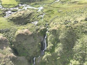
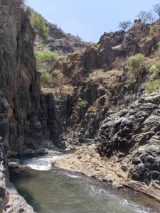
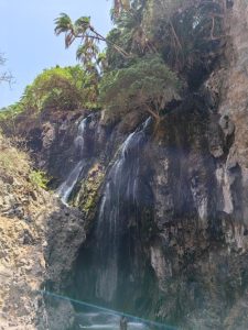
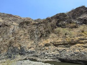
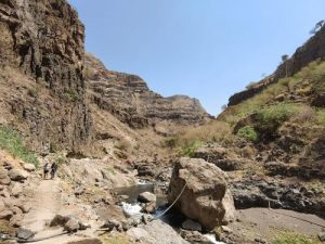
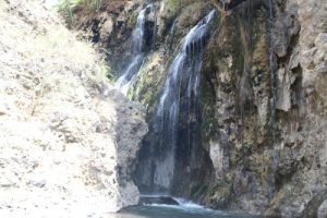
A waterfall is a landform formed by the vertical drop of water along a steep slope or cliff in the riverbed. In geology, it is called a waterfall and is formed by the combined action of the Earth’s internal and external forces. Where there are waterfalls, the river always erodes upstream, continuously disintegrating the upper part of the waterfall, causing rock layers to break and fall. As a result, the position of the waterfall gradually recedes towards the upstream direction, and the drop of the waterfall also decreases. The Ngareselo Falls are located in the Ngareselo Canyon downstream of the Saitoti River (Figure 1). The Saitoti River originates from the northern slope of the Empakaai volcano, and its water flows down a winding and steep canyon before eventually merging into Lake Natlon. The Ngareselo Falls is approximately 2 km away from the Worldview Campsite and Lodge campsite in a straight line. At the observation point, a continuous stream of clear water can be seen falling along the rock wall into the lower pool. The water flow is like a white curtain, with a large volume and fast flow rate, hanging down from a height of about 30 meters. The lower pool water is clear and bottomed out (Figure 2), which is very suitable for swimming enthusiasts. It takes about 45 minutes of walking along the river from the entrance of the canyon to the waterfall landscape. There is a karst cave at the bottom of the rock wall of Engareiro Falls, and the water flows down, resembling a water curtain cave. According to the height to width ratio of the waterfall water flow, the Engareiro Waterfall is a vertical curtain waterfall with nearly vertical rock walls, therefore it belongs to the vertical waterfall category.
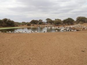
The lake is approximately circular in shape on the plane, with a water area of about 4000 square meters. It may have been formed by the accumulation of precipitation in low-lying terrain or supplemented by spring water (Figure 1). The vegetation on the north bank of the lake is relatively dense, making it a seasonal lake with a significant difference in water levels between dry and wet seasons. The lake water is relatively clear and emerald green, with a large amount of green algae developing on the lake surface near the north bank. This lake is an important drinking water source for local livestock