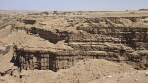
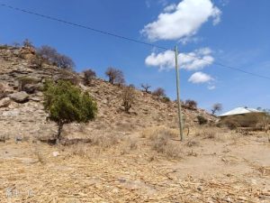
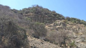
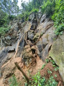
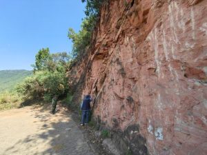
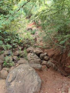
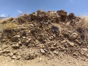
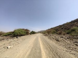
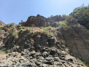
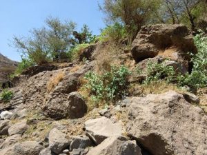
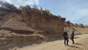
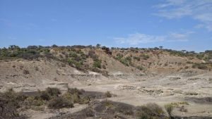
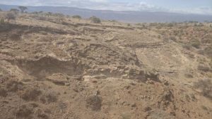
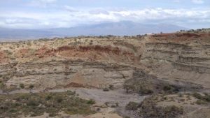
Disaster Introduction
Hidden danger points of Mengba Giant Rock collapse
The geomorphic unit of this point is a basin, with a steep slope and a block like structure composed of granite. The rock is strongly weathered, with well-developed joints and fissures. The vegetation is mostly shrubs, with a small amount of trees, and there is no human engineering activity. The collapse source is formed by a steep and negative terrain, with a length of about 150 meters, a width of about 10 meters, and a thickness of about 2 meters. A set of joint fissures is developed, with a convex shape on the plane. The rock is granite, and the weathering is relatively strong. The collapse path is to fall down the slope and then roll down to the foot of the slope, with a small amount of scattered rolling stones currently present. The hidden danger point of the collapse is currently in the initial cracking stage, with a small amount of scattered rolling stones and no obvious cracks in some areas at the slope corner. It is currently in a basically stable state and may experience instability under the influence of rainfall, earthquakes and other triggering factors, leading to collapse. It poses a threat to the road below Mengba Giant Rock and local pedestrians. As the road is a simple road with fewer people passing by, the degree of harm is relatively low.
Disaster photo

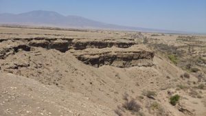
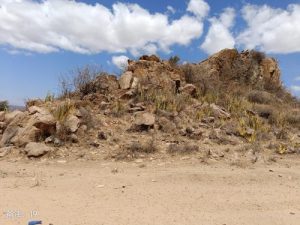
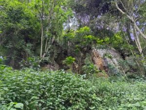
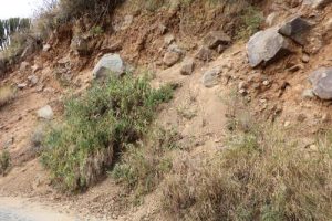
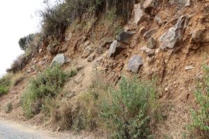
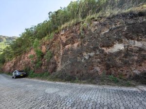
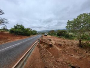
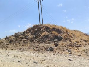
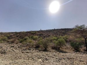
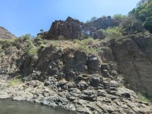
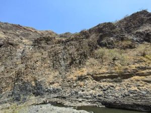
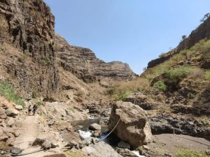
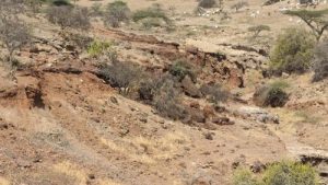
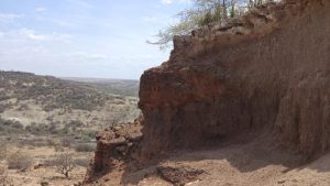
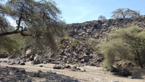
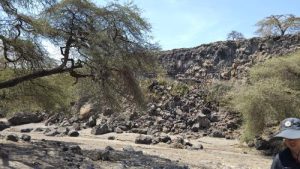
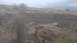
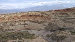
Disaster Introduction
Hidden danger point of collapse 300m south of Mengba Giant Rock
The geomorphic unit of this point is a basin, with a steep slope and a gneiss like structure. The joints and fissures are well-developed, and there are sparse shrubs on the slope top and fracture surface, without human engineering activities. The terrain slope of the collapse source area is about 550 meters, with a length of about 150 meters, a width of about 10 meters, and a thickness of about 4 meters. The rock is composed of gneiss, metamorphic structure, gneiss like structure, developed joint fissures, and a rock block size of about 0.6 x 1.5 x 2 meters. The rock is strongly weathered. The collapse path is for the collapse body to slide along the joint and fissure surface to the slope corner. The hidden danger point of collapse is currently in a basically stable state, with well-developed joints and cracks. Under the influence of triggering factors such as rainfall and earthquakes, collapse may occur. This hidden danger mainly poses a threat to nearby residents, including 7 households with about 30 people, 7 brick and concrete houses, and 6 adobe houses, posing a threat to property worth 280000 yuan. The number of threats ranges from 10 to 100 people, with a moderate degree of harm.
Disaster photo
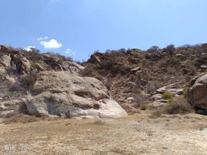
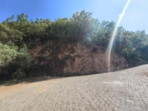
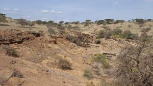
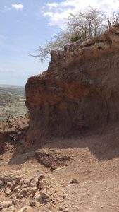
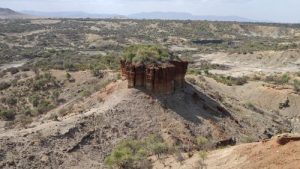
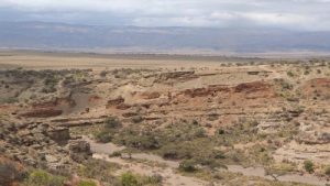
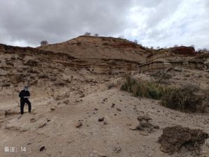
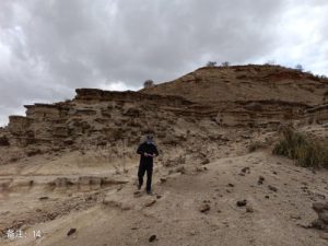
Disaster Introduction
Collapse hazard point of No.1 tourist road on Lake Aiyaxi
The geomorphic unit of this point is a basin, with a steep slope as the micro landform. The lithology is granite, with a medium to coarse grain structure and a block like structure. The rock is strongly weathered, with well-developed joints and fissures. The vegetation is shrubs, and there is no human engineering activity. The collapse source is an isolated and dangerous rock mass, approximately 25m long, 12m high, and 5m wide. The rock is granite with strong weathering and currently has joints and cracks. The collapse path is to fall down the slope and then pile up to the foot of the slope. Currently, there are scattered deposits in the collapse path area. The hidden danger point of the collapse is currently in the initial cracking stage, with developed joints and cracks on the slope. It is currently in a basically stable state and may become unstable under the influence of triggering factors such as rainfall and earthquakes, resulting in collapse. This point is an isolated and dangerous rock mass, with a height of about 12m and a length of about 25m. There is relatively little human activity and the degree of harm is small.
Disaster photo

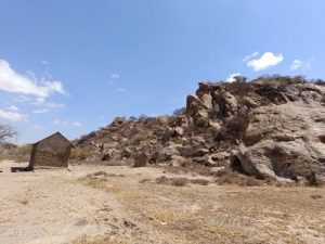
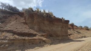
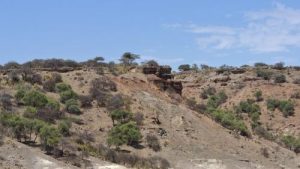
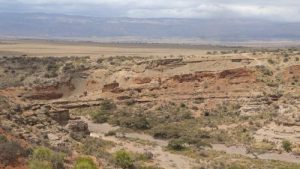
Disaster Introduction
Collapse hazard point of No.2 tourist road on Lake Aiyaxi
The geomorphic unit of this point is a basin, with a steep slope as the micro landform. The lithology is granite, with a medium to coarse grain structure and a block like structure. The rock is strongly weathered, and the vegetation is shrubs. There is no human engineering activity. The collapse source is formed by steep slope terrain, with a length of about 100m, a width of about 3m, and a thickness of about 2m. The joint fissures are well-developed, and the rock is granite with strong weathering. The collapse path is that the rock falls downwards along the structural plane under the combination of weathered joints and fissures, and accumulates at the slope angle under the inducing factors. The hidden danger point of the collapse is currently in the initial cracking stage, with a small amount of scattered rolling stones in some areas. It is currently basically stable and may become unstable under the influence of triggering factors such as rainfall and earthquakes, resulting in collapse. This hidden danger mainly poses a threat to nearby residents, including 2 households with about 12 people, 3 brick and concrete houses, and 2 adobe houses, posing a threat to property worth 160000 yuan. The number of threats ranges from 10 to 100 people, with a moderate degree of harm.
Disaster photo
Disaster Introduction
Collapse hazard point 400m southwest of the scenic spot of Lake Aiyaxi
The terrain and topography of this point are Zhongshan, with steep cliffs as the micro terrain. The upper part is composed of calcareous tuff, gray white, with multiple sets of vertical joints. The bottom is composed of basalt, gray black, and the slope is nearly horizontal layered. The vegetation is shrubland, and human engineering activities are road construction. The collapse source area is mainly a dangerous rock mass formed by calcareous tuff due to columnar joints, with a spacing of about 1 meter and a depth of about 8 meters between the columnar joints. The collapse path area is a dangerous rock mass that rolls and jumps on the slope after dumping, with a maximum distance of about 60m. At present, the dangerous rock mass is in a basically stable state, and may experience instability and collapse under triggering factors such as rainfall and earthquakes. This is an undeveloped scenic spot, with inconvenient road traffic and limited human traffic, resulting in a low level of harm.
Disaster photo
Disaster Introduction
Hidden danger point 1 of elephant cave collapse
The terrain of the collapse site is steep, almost upright, and the terrain is mountainous. The lithology of the formation is tuff block structure, with developed unloading cracks. On the left is a gully without water, with high vegetation coverage, mostly trees, shrubs, and grass, and no human engineering activities. The source area of the collapse is volcanic rock, with a fine-grained structure and a block like structure. The unloading cracks are developed, and the rock blocks are approximately (0.5-2) long x (0.5-1) wide x (3-5m) high. The cracks are 2-10cm wide, with no filling – a small amount of filling, and the crack surface is rough. The collapse path tilts downwards along the slope, rolling down the foot of the slope, and the falling rocks are about 30 x 40 x 50cm The hidden danger of collapse is currently in a basically stable state, and collapse may occur in the future under factors such as rainfall and earthquakes This hidden danger mainly poses a threat to tourist mountaineers, with a relatively low degree of harm.
Disaster photo
Disaster Introduction
Hidden danger point 2 of elephant cave collapse
Disaster photo
Disaster Introduction
The collapse point 1 of the Ngoro Ngoro crater
The surrounding terrain of this hidden danger point is steep, with a slope of 50-70 °. The terrain is a low mountain in a volcanic crater, and the roadbed slope is manually excavated. The lithology of the formation is a mixture of Quaternary residual soil and rock mixed with crushed stone soil. The soil is completely weathered tuff powder, with a crushed stone content of about 50-70%. The block size is 3-150cm, and the sorting is poor, with an angular shape. The parent rock is composed of tuff (volcanic rock), and there is no water in the surrounding area. The surface vegetation is covered, mainly by herbs and shrubs, Human engineering activities mainly involve excavating mountain roads, with a roadbed width of approximately 3-4m The source area of the potential collapse hazard is the slope of the entrance road to the Engro Huoshan Pass, which is residual gravel soil with a maximum block diameter of up to 1.5m. The slope is steep, with a slope of 60 ° -80 °. The roadbed side is exposed, with visible fragments, with a block diameter of 10-30cm. The upper part of the slope is covered with vegetation. The collapse path falls downwards along the slope to the foot of the slope, with a maximum distance of 50m along the slope, usually 20m, and piles up at the foot of the slope. The hidden danger point is currently in a basically stable unstable state, with a small amount of falling stones visible on the roadbed. In the future, under triggering factors such as rainfall, larger stones may fall, affecting the safety of passing vehicles. The hidden danger point is currently in an unstable state and is prone to collapse under triggering factors such as rainfall and vibration excavation, causing harm to passing tourist vehicles with a moderate degree of harm. Tourist vehicles can accommodate 5-9 people, with a moderate to high degree of harm.
Disaster photo
Disaster Introduction
Hidden danger point 1 of the collapse at the exit of the Engoro volcano crater
The surrounding terrain of this point is steep, with a natural slope of 40-60 ° and an artificial slope of 80 °. The excavation face is about 10 meters high, and at the foot of the slope is a boundary between granite and tuff. The upper part of the tuff has a pink surface and a greenish gray interior, with a cryptocrystalline structure, block like structure, developed joints, and a relatively broken upper rock mass. The excavation surface is exposed, and the rest of the vegetation is covered. The roadbed is about 3 meters wide, and this is a turning point. The road is paved with crushed stone bricks, and there are no other human engineering activities. The collapse source area is an artificially excavated surface, which is nearly upright. The rock structure on the slope is relatively fragmented, with developed joint fissures and a width of about 1-2cm The collapse path falls downwards along the slope and is piled up at the foot of the slope. The maximum distance of the collapse reaches the bottom of the volcanic crater below the slope. The diameter of the rolling stones is relatively small, usually 5-30cm, and they fall irregularly in a straight line. The hidden danger point of the collapse is currently in a basically stable state, with some parts in an unstable state. In the future, it may lead to rockfall and other collapse phenomena under triggering factors. The volume of the collapse source is about 5000m3, which can cause rockfall under triggering factors, with a moderate degree of harm, mainly endangering passing tourist vehicles.
Disaster photo
Disaster Introduction
Hidden danger point 2 of the collapse at the exit of the Engro crater
The surrounding terrain of this hidden danger point is steep, with a slope of 40 ° -60 °. The point is a manually excavated roadbed slope, with a steep slope surface of nearly 90 °, exposed, and composed of volcanic conglomerate and fragmented structure. The slope surface is devoid of vegetation, and the foot of the slope is a manually constructed road of about 4 meters. The main source area of collapse is the slope formed by manual excavation of the roadbed, with exposed excavation surface and broken rock mass, with a height of about 10-15m and a length of about 80-100m. The collapse is mainly caused by external forces on the upper and middle rock masses, and the original slope surface above the excavation surface is covered with vegetation. The collapse path mainly falls downwards along the slope, with the most likely vertical distance of 15m and a horizontal distance of 2-5m. The falling stones are mainly piled up at the foot of the slope roadbed, and a small amount can roll along the original slope surface to the bottom of the volcano. The hidden danger point is close to upright and in a state of ultimate equilibrium, which may cause collapse phenomena such as falling blocks and rocks under external forces. The hidden danger point is formed by manual excavation to form a nearly upright roadbed slope, which is most likely to cause falling stones along the excavation surface, endangering the safety of passing tourist vehicles and tourists, with a moderate degree of harm.
Disaster photo
Disaster Introduction
Hidden danger point 3 of collapse at the exit of the Ngoro crater
The surrounding terrain of this hidden danger point is steep, with a slope of 40 ° -60 °. The terrain type is volcanic crater, medium low mountain terrain, and the lithology of the formation is volcanic conglomerate. The slope is a high and steep slope formed by manual excavation of the roadbed, with broken rock mass and no groundwater. The excavation surface shows exposed bedrock, with other vegetation covering it. The roadbed is about 3m wide, paved with crushed stone bricks, and there is no other human engineering activities. The collapse source area is a manually excavated slope, with a steep excavation surface and fragmented rock mass. The size of the rock blocks is 1.5 x 1.0 x 0.5 meters, and the local bedrock is exposed to volcanic conglomerate, with the remaining vegetation covering it. The collapse path falls or rolls down the slope, mostly piled up at the edge of the roadbed, and a small amount rolls down the original slope to the lower part of the volcano. The hidden danger point of the slope is currently in a basically stable state. Due to the fragmentation of the slope rock mass, external forces may induce rockfall and other collapse disasters. The hidden danger point is formed by manually excavating the roadbed to form a steep slope, which can cause collapse phenomena such as falling rocks under external forces, endangering the safety of passing tourist vehicles and tourists, but the degree of harm is not high.
Disaster photo
Disaster Introduction
Karatu collapse hazard point 1
The surrounding terrain of this point is steep, with a terrain of medium to low mountains and hills, with a slope of 30-50 °. The lithology of the strata is volcanic tuff and volcanic ash, a combination of hard and soft strata. The area is also formed by manual excavation, with a slope of about 60-70 °. The rock mass is fragmented, and the surrounding vegetation is covered. Below the foot of the slope is farmland. The collapse source area is located on the south side of the highway, forming a free face for road construction and excavation. The rock mass in the source area is broken and fragmented, with a diameter of 30-80cm. The residual soil on the surface slope is thin, 10-30cm, covered with vegetation, and the free face is exposed. The collapse path rolls down the slope, piled up at the edge of the roadbed, and can roll down to the farmland at the farthest point. The slope is currently in a basically stable unstable state, and during the rainy season, it can cause the rolling of rocks under the induction of rainfall. The hidden danger point is currently in a basically stable unstable state, which can form collapse under triggering factors such as rainfall, seriously affecting the safety of passing vehicles and personnel, with a moderate degree of harm.
Disaster photo
Disaster Introduction
Sella collapse point
The terrain of the collapse site is steep, with hilly terrain and volcanic rock formations. The rock mass is fragmented and has developed joints, with a slope of 40-70 °. Most of the surface has been exposed, with a small number of cactus trees visible. There is only one road around, paved with gravel, and no other human engineering activities. The terrain of the collapse source area is steep, with a slope of 50 ° -70 °. The rock mass is fragmented, with vertical joints developed, and the rock mass is fragmented, with a block size of about 0.3 × 0.5 × 1.5m The collapse path falls down along the mountain, with a path that is approximately straight and piled up at the foot of the slope. The collapse point is currently in a basically stable unstable state, and can cause collapse phenomena such as falling rocks under triggering factors such as rainfall and earthquakes. The collapse point mainly falls down the mountain in the form of rolling stones, which mainly endangers the safety of pedestrians and vehicles passing by the slope foot road, and the degree of harm is relatively small.
Disaster photo
Disaster Introduction
Kidumbein collapse hazard points
This point is located in a gully, with volcanic breccia as the lithology. The steep slope is nearly upright, with a combination of tuff/breccia/tuff. The surface is covered with shrubs and a small amount of trees. There is a road at the top of the slope, which is about 5m wide and paved with gravel. The top of the collapse source slope is relatively gentle, and the slope surface is nearly upright, consisting of volcanic breccia with developed vertical joints and unstable rock structure. The collapse path tilts downwards along the slope and rolls into the ditch. The collapse hazard point is currently in a state of extreme equilibrium and can cause collapse under factors such as rainfall. The hidden danger point is located on the east side of the highway roadbed, collapsing towards the direction of the highway, endangering the highway and passing vehicles and pedestrians, with a relatively low degree of harm.
Disaster photo
Disaster Introduction
Hidden danger points of Lungai collapse
The surrounding terrain of this point is relatively gentle, with a slope of 5-15 °. The terrain type is volcanic terrain, and the rock layers in this area are piled up with crushed stones, disorderly and disorderly, with a block size of 2-500mm. The sorting is poor, and the grading is good. The artificial excavation forms a slope of nearly 80 °, without water. The surface is covered with vegetation mainly composed of grass and shrubs. The collapsed park is a small hill that may have been formed by volcanic eruption and accumulation. The gravel is disorderly and of varying sizes, with a slope gradient of about 15 °. The artificial excavation forms a slope of about 80 °, with vegetation covering the top of the slope and the slope surface exposed. The collapse path falls down along the excavation face to the highway. The potential collapse point is currently in a limit equilibrium state, and may collapse under rainstorm, manual excavation and other factors. The scale of the collapse hazard point is relatively small, mainly causing harm to passing vehicles and pedestrians, and the degree of harm is relatively low.
Disaster photo
Disaster Introduction
Hidden danger points of the collapse of the Lungai volcano crater
This point is located 180m away from the west side of the Lungai volcanic crater, where cracks are developed. The surrounding terrain is steep, with a slope of 30-50, and the terrain type is volcanic crater landform. The surface lithology is volcanic breccia, tuff, gray black, layered, with a rock attitude of 312 ° ∠ 15 °. The rock strength is high, and the gravel diameter is about 2-50mm, with a maximum of 100mm. It is in an angular to sub angular shape, and the surface of the rock layer is accompanied by white carbonate rock with good crystallization, resembling cauliflower. A crack with a width of about 20-50cm is developed in the source area of the collapse, and H2S gas is locally emitted. The outer rock structure is composed of volcanic breccia and tuff, with an inclination angle of about 20 °. The collapse path is prone to collapse towards the foot of the mountain under the action of vibration. The hidden danger point is currently in a basically stable state, and instability may occur under the action of earthquakes or volcanic eruptions and vibrations The collapse hazard point is prone to collapse towards the foot of the mountain under the action of vibration. Due to the lack of human habitation and fewer tourists going up the mountain, the degree of harm is relatively low.
Disaster photo
Disaster Introduction
Engaresero collapse hazard points
The surrounding terrain of this point is relatively undulating, with a slope of 5 ° -30 °. The terrain type is medium low mountain terrain, and the lithology of the stratum is basalt. The slope at this point has a slope of about 15 ° -30 °. The rock mass on the slope is fragmented, with a block diameter of 10-30cm and an angular shape. There are many trees around, with a height of about 5-18m and a thickness of about 10-20cm. Herbs, shrubs, and other vegetation can be seen on the slope. The slope gradient of the collapse source area is about 30 °, and the rock structure is fragmented, presenting a fragmented to scattered shape with a block diameter of 20-30cm and an angular shape. Herbs and shrubs can be seen on the slope surface. The collapse path rolls downstream along the slope. At present, the slope is in a basically stable state, and under the action of heavy rain or earthquakes, the stones on the slope will roll down along the slope. The slope is currently in a basically stable state, with landslides occurring mainly during the rainy season. The dry season has little impact on the safety of passing vehicles and pedestrians, and the degree of harm is low.
Disaster photo
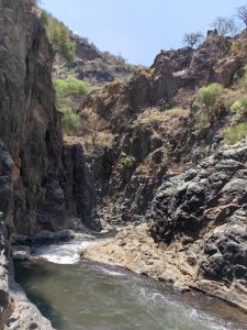
Disaster Introduction
Ngaresero Waterfall Collapse Hazard Point 1
This point is located within a mountain canyon, with steep terrain and a slope of 50-90 °. The terrain type is high mountain canyon terrain, with basalt as the main lithology and locally mixed with volcanic breccia, tuff, etc. The surrounding slope is steep, with basalt as the lithology. The columnar joints are developed, and the rock mass is hard. A river is developed, with a water surface width of about 2-3cm, a water depth of 1-1.5m, and a flow rate of 2-3m/s. The surface layer of the rock mass at the waterfall is calcareous and covered with vegetation. The slope of the collapse source area is steep, with developed joints and fissures, and the rock structure is relatively fragmented. The surface of the rock mass at the waterfall is calcareous, and the vegetation at the water source is developed, with a large number of trees visible. The collapse path descends along the slope and accumulates in the valley. The point is currently in a basically stable state and is prone to collapse under the effects of rainfall, earthquakes, weathering and unloading. This hidden danger mainly poses a threat to tourists traveling to the waterfall area, with a relatively mild degree of harm.
Disaster photo
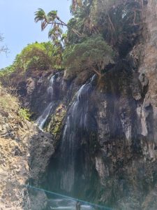
Disaster Introduction
Ngaresero Falls Collapse Point 2
The surrounding terrain of this point is steep, and the landform type is canyon landform. The lithology of the strata is mainly basalt, volcanic breccia, and tuff. The slope at this point has a slope of 70-90, and the rock mass is columnar with developed vertical joints. The valley bottom is a perennial small river, and there is a small waterfall at the slope, which is about 30-50cm wide and flows into the small river. The slope of the collapse source area is steep, with developed joints and fissures, covered with a small amount of shrubs, and the rock mass is fragmented. The collapse path tilts downwards along the slope and piles up in the valley. The hidden danger point is currently in a basically stable state, and may experience rock collapse and other phenomena under triggering factors such as rainfall and earthquakes. This hidden danger mainly endangers tourists entering the canyon, with a relatively low degree of harm.
Disaster photo
Disaster Introduction
Ngaresero Falls Collapse Point 3
The surrounding terrain of this point is steep, with a landform type of high mountain canyon. The lithology of the stratum is mainly basalt, interbedded with tuff and volcanic breccia. The slope is steep, with developed cracks and fragmented rock mass. A perennial river is developed in the valley, and the surface is covered with a small amount of vegetation. The slope of the collapse source area is steep, with developed joints and fissures, mainly consisting of two sets of joints. The rock mass is mostly columnar and relatively fragmented. The collapse path tilts downwards along the slope. At present, the slope is in a basically stable state and is prone to instability and collapse under the effects of rainfall, earthquakes, and other factors in the future The collapse hazard mainly poses a threat to the safety of passing travelers, with a relatively low degree of harm.
Disaster photo
Disaster Introduction
Ngaresero Falls Collapse Point 4
The surrounding terrain of this point is steep, with a slope of 30-80 degrees. The terrain type is high mountain canyon terrain, and the lithology of the strata is mainly basalt, with locally interbedded tuff and volcanic breccia. The basalt on the slope has developed vertical joints. The rock mass and joints in the collapse source area are well-developed, with steep slopes and relatively fragmented rock mass, with exposed bedrock. The collapse path collapses downwards along the slope and piles up at the foot of the slope. The surrounding rock mass at this point is currently in a basically stable state, and is prone to instability under factors such as rainfall and earthquakes, leading to collapse. This hidden danger mainly poses a threat to passing tourists, but the degree of harm is relatively low.
Disaster photo
Disaster Introduction
Audewey Canyon No.1 Collapse Hazard Point
The landforms of the collapse site are plateau canyon landforms, with micro landforms of gullies. The lithology of the surface layer is gray white tuff, and the lower part is brownish red sandstone. The slope structure is a rocky slope, with sparse forests and grasslands as vegetation, and no human engineering activities. The terrain is cut by floods to form steep ridges, and the collapse source is formed by unloading cracks on the steep ridges. The length of the collapse source is about 50m, the width is about 3-5m, and the height is about 5-10m. The unloading cracks tend to be upright, with a width of about 10-20cm and no filling material. Pour downwards along the slope, roll off the foot of the slope, and the collapsed block is about 0.3 x 0.5 x 0.8m. At present, it is basically stable, and there is a possibility of another collapse under rainfall in the future There are no direct hazards, posing a threat to herders, and the degree of harm is low.
Disaster photo
Disaster Introduction
Audewey Canyon No. 2 Collapse Hazard Point
The terrain of the collapse site is steep and almost upright, with a plateau canyon landform. The lithology of the stratum is volcanic ash soil, with low vegetation coverage, mostly grassland and sparse shrubs. The slope is located on the right side of the road, formed by cutting the slope during road construction The source area of the collapse is volcanic ash soil, which is brownish red, hard, and presents a tilting angle. It is currently in the initial cracking stage. It is predicted that it will tilt downwards along the slope and roll down to the foot of the slope. At present, it is in a basically stable state and may collapse in the future due to factors such as rainfall and earthquakes Mainly aimed at posing a threat to passing vehicles, with fewer vehicles coming and going, and a low degree of harm.
Disaster photo
Disaster Introduction
Audewey Canyon No. 3 Collapse Hazard Point
The terrain at this point is a plateau canyon terrain, with a micro terrain of steep slopes formed by river erosion. The surface layer is 1m thick tuff, and the lower part is 4-6 meters of red sandstone. The lower part is gray white sandstone, with strong weathering of the rocks and shrubs as vegetation. There is no human engineering activity. The main source of collapse is formed by the negative terrain of steep slopes. The length of the collapse source is about 150m, the width is about 3-5m, and the thickness is about 4-8m. Currently, there are no structural cracks such as unloading cracks, and it forms a “convex” shape on the plane. It is the steep slope left by river erosion and erosion, with a slope of about 95 °. The surface of the rock is tuff, and the lower part is sandstone. The rock is strongly weathered. Falling down the slope and rolling down to the foot of the slope, there is currently accumulation of debris in the collapse path area, with a slope of about 45 °. The point is currently in the initial cracking stage, with a small amount of accumulation in some areas, which may cause instability and collapse under triggering factors such as rainfall. It poses a threat to tourists on the scenic trail and has a low degree of harm.
Disaster photo
Disaster Introduction
Audewey Canyon No. 4 Collapse Hazard Point
The terrain at this point is plateau canyon terrain, with a micro terrain of steep slopes formed by river erosion. The surface layer is 2m thick tuff, and the lower part is red sandstone. The rock is strongly weathered, and the vegetation is shrubs, with no human engineering activities. The main sources of collapse are the hanging upper tuff caused by weathering and erosion of the lower sandstone, as well as the formation of an upright slope preserved by weathering and erosion of the lower sandstone, with a length of about 50m, a width of about 3m, and a thickness of about 3-8m. Currently, there are unloading cracks. Falling down the slope and rolling down to the foot of the slope, there is currently accumulation of debris in the collapse path area, with a slope of about 45 °. The point is currently in the initial cracking stage, with vertical unloading cracks at the top of the slope, which is basically stable. In the future, collapse may occur under factors such as rainfall, earthquake, and weathering The impact on tourists is relatively small and the degree of harm is low.
Disaster photo
Disaster Introduction
Audewey Canyon No. 5 Collapse Hazard Point
This point is located in a plateau canyon landform, with a lithology of basalt, gray black, porous structure, developed joints and fissures, and vegetation of shrubland land without human engineering activities. The collapse source is formed by the erosion of the riverbank by the river. The collapse source is 60m long and 3m wide, with developed joints and cracks. With the erosion of the river, there is a possibility of further expansion. Under the inducing factors, slide downwards along the structural plane and accumulate at the foot of the slope. Cutting blocks may experience instability and form sliding collapse under triggering factors such as heavy rainfall and earthquakes. This point is far away from the Audewey observation deck, posing a small threat to tourists and may cause river blockages, with a low degree of harm.
Disaster photo
Disaster Introduction
Audewey Canyon No. 6 Collapse Hazard Point
The terrain at this point is a plateau canyon terrain, with a micro terrain of steep slopes formed by river erosion. The upper part is red sandstone, and the lower part is gray white sandstone. The rock weathering is strong, and the vegetation is shrubs, with no human engineering activities. The collapse point is a solitary hill formed by river erosion and weathering, with multiple unloading cracks around it. The cracks are upright and have a depth of about 10m. After the collapse, the material rolls down the slope to the foot of the slope. The slope has multiple sets of vertical unloading cracks, some of which have reached the foot of the slope and are prone to instability and collapse under triggering factors such as rainfall and earthquakes. This is the core attraction of the Ouduwei Canyon, about 50m away from the observation deck. As tourists generally do not go to the foot of the slope, the degree of harm is relatively small.
Disaster photo
Disaster Introduction
Audewey Canyon No. 7 Collapse Hazard Point
The terrain at this point is a plateau canyon terrain, with a micro terrain of steep slopes formed by river erosion. The upper part is red sandstone, and the lower part is gray white sandstone. The rock weathering is strong, and the vegetation is shrubs, with no human engineering activities. The collapse point is a solitary hill formed by river erosion and weathering, with multiple unloading cracks around it. The cracks are upright and have a depth of about 10m. After the collapse, the material rolls down the slope to the foot of the slope. The slope has multiple sets of vertical unloading cracks, some of which have reached the foot of the slope and are prone to instability and collapse under triggering factors such as rainfall and earthquakes. This is the core attraction of the Ouduwei Canyon, about 50m away from the observation deck. As tourists generally do not go to the foot of the slope, the degree of harm is relatively small.
Disaster photo
Disaster Introduction
Audewey Canyon No. 8 Collapse Hazard Point
The terrain of this point is steep, with a plateau canyon landform. The lithology of the stratum is sandstone, with medium to coarse grain structure, block structure, and developed joints and fissures. The left side is a canyon, with no water inside and little vegetation. The Maasai people graze here, and no human engineering activities have been seen. The source area of the collapse is sandstone, with a medium to coarse grain structure, block like structure, and well-developed joint fissures. The block is about 0.4 × 0.3 × 1m, and the fissure width is about 1cm. There is no filling, and the fissure surface is rough. Falling down the slope and rolling to the foot of the slope, the collapsed block is about 0.4 × 0.3 × 0.8m. The point is generally in a stable state, and may experience collapse phenomena such as falling blocks under triggering factors such as rainfall and earthquakes. It mainly poses a threat to tourists, hikers, and herders, with a low degree of harm.
Disaster photo
Disaster Introduction
Hidden danger point of the 9 collapse in the Audewey Canyon
The terrain of this point is steep, with a plateau canyon landform. The lithology of the stratum is sandstone, with medium to coarse grain structure, block structure, and developed joints and fissures. The left side is a canyon, with no water inside and little vegetation. The Maasai people graze here, and no human engineering activities have been seen. The source area of the collapse is sandstone, with a medium to coarse grain structure, block like structure, and well-developed joint fissures. The block is about 0.3 × 0.2 × 0.4m, and the fissure width is about 3cm. There is no filling, and the fissure surface is rough. Dumping downwards along the slope, rolling down to the foot of the slope, the collapsed block is about 0.3 × 0.2 × 0.3m. The point is generally in a stable state, and may experience collapse phenomena such as falling blocks under triggering factors such as rainfall and earthquakes. It mainly poses a threat to tourists, hikers, and herders, with a low degree of harm.
Disaster photo
Disaster Introduction
Audewey Canyon No. 10 Collapse Hazard Point
The terrain of this point is steep, with a plateau canyon landform. The lithology of the stratum is sandstone, with a medium to coarse grain structure and a block like structure, with developed unloading cracks. The right side is a canyon, without water and with little vegetation. The Maasai people graze here, and no human engineering activities have been observed. The source area of the collapse is sandstone, with a medium to coarse grain structure and a block like structure. The unloading fractures are developed, with a block size of about 0.5 x 0.4 x 0.3m and a crack width of about 2cm. There is no filling, and the crack surface is rough. Falling down the slope and rolling to the foot of the slope, the collapsed block is about 0.4 × 0.2 × 0.3m. The point is generally in a stable state, and may experience collapse phenomena such as falling blocks under triggering factors such as rainfall and earthquakes. It mainly poses a threat to tourists, hikers, and herders, with a low degree of harm.
Disaster photo
Disaster Introduction
Audewey Canyon No. 12 Collapse Hazard Point
The landform of this point is a plateau canyon landform, with a rock formation consisting of 10cm thick volcanic ash in the upper part and about 2m thick calcareous tuff in the lower part. The tuff is gray white, with a block like structure. Below the tuff is sandstone, interbedded with gray white and reddish brown, with a medium to coarse grain structure and layered structure. No groundwater is observed, and there is no human engineering activity. The main source of collapse in this area is the upper sandstone below the calcareous tuff, with a thickness of about 20m and a width of about 4m, and strong weathering. The collapse path is composed of sandstone in the lower part of calcareous tuff, with a slope of about 80 °, which is prone to toppling collapse. Currently, there is a deposit of debris in the collapse path, with a slope of about 50 °. The point is currently in an accelerated deformation stage, with a small amount of accumulated material in some areas. It is currently in a basically stable state and may experience instability and collapse under triggering factors such as heavy rainfall. The threat target of this hidden danger point is herders, without a fixed threat target, and the degree of harm is low.
Disaster photo